DISPATCH №001 · Higashi-Iwase
Built by the trade, kept by the merchants, rebuilt by the people who came back.
Higashi-Iwase, Toyama / PUBLISHED 2026.07
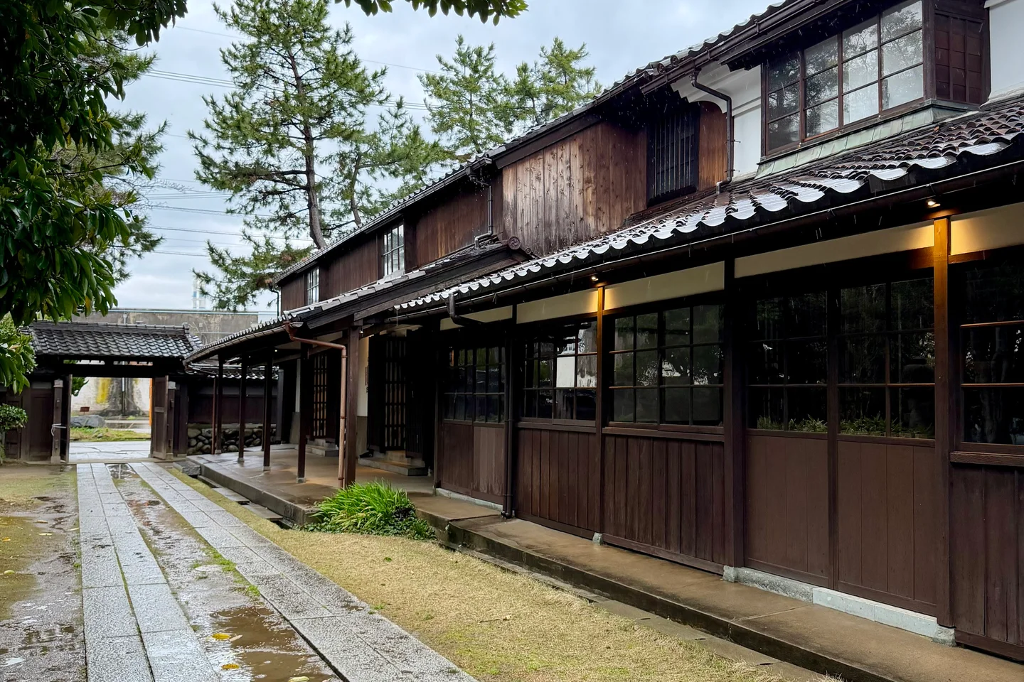
North of Toyama city, at the end of a light-rail line that most visitors never board, a four-hundred-metre stretch of street has had its overhead wires removed. The pavement underfoot is unusually pale. There are no power poles in the photograph. The first thing the eye registers is not what is there but what has been taken away. This is Higashi-Iwase. It was once one of the most concentrated trading ports on the Japan Sea, and the buildings that financed that trade are still standing. The town is now in the slower work of deciding what those buildings are for next.
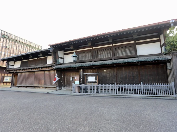
The Former Baba Family Residence, a Kitamae-bune Shipping Merchant
The port of 東岩瀬 / Higashi-Iwase did not begin by design. In 1658, a flood shifted the 神通川 / Jinzu River eastward and deposited the function of a harbour onto what had been unremarkable coastline. The river had cut a new mouth, and a new mouth meant a new place to load and unload ships.
Within a generation, the lords of 加賀藩 / Kaga han had built rice storehouses here. The port was registered in the medieval cartographic tradition as one of the 三津七湊 / sanshin-shichisō — the three crossings and seven harbours that organized the early-modern Japanese coast — under the name 岩瀬湊 / Iwase-minato. Rice from the domain's interior moved through the storehouses and onto ships bound for Osaka. Higashi-Iwase had entered the trade network that would define the Japan Sea for the next two centuries.
The network is called 北前船 / Kitamaebune: the northern ships. The name barely does them justice. These were not freight carriers earning a fee for moving other people's goods. The shipowners bought outright at every stop, reselling at the next port for whatever the market would bear — a practice called 買積 / kaidzumi, buy-stacking. The information gap between coastlines made it extraordinarily lucrative. The local name for these vessels was バイ船 / bai-sen — the doubling ships, after the compounding returns.
Herring meal (鰊粕 / nishinkasu) was cheap and plentiful in Hokkaido and worth several times as much in the rice paddies of western Japan, where farmers had discovered it was among the fastest ways to raise a crop yield. Silk, salt, and cotton went north. Kelp, herring, dried salmon, and fish oil went south. A single successful voyage could return the equivalent of two billion yen in today's money. Higashi-Iwase sat at one of the busiest interchanges in this system.
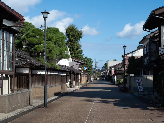
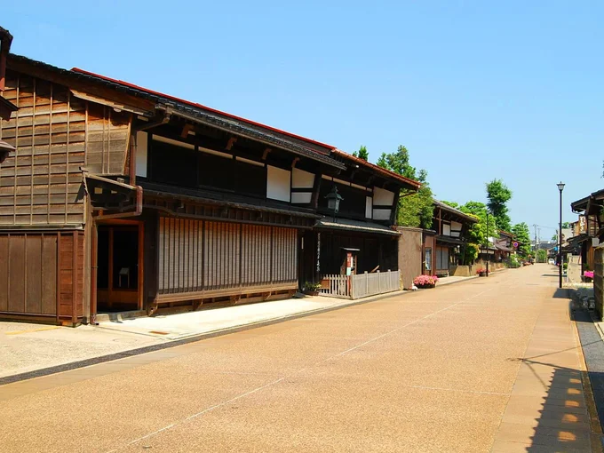
At its height, eighty merchant houses lined the four hundred metres of 岩瀬大町・新川町通り / Iwase Omachi and Shinkawa-cho. Each fronted by a screen of thin horizontal bamboo slats. Each backed by a long earthen corridor leading directly to a berth on the canal. The town was not a port with merchants attached; it was a continuous façade of merchants, the port behind them.
The Kitamaebune era peaked in the mid-19th century. Steam shipping and the new railways carried the freight differently, and between 1901 and 1903 a flood-control project — the 馳越線 / Hayakoshi-sen cut on the Jinzu River — redirected the channel and removed Iwase's reason to exist as a port. By 1943 the name was changed to 富山港 / Toyama-kō; the modern industrial harbour shifted south. What remained on the old four hundred metres of street were the buildings. The lacquer-plaster relief carvings on the storehouse doors still showed dragons and tigers. The flagstones in the corridors still came from 小豆島 / Shōdoshima. The buildings were waiting to be used for the next thing.
Set sail for Higashi-Iwase →A port can disappear from the trade routes without disappearing from the ground. Four things to look for on the four-hundred-metre street.
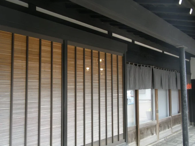
Evidence 1 — スムシコ / Sumusiko · The optics of the screen
The merchant façades are fronted by スムシコ / sumusiko — a screen of thin bamboo slats, set horizontally on the lower storey and vertically on the upper. The geometry is not decorative. From inside the house, you can see clearly through it to the street. From the street, you can see almost nothing inside. The merchants of Higashi-Iwase were not shy about accumulating wealth. They were careful about where it was visible. The screen was the physical expression of that calibration. It is still there, in front of dozens of buildings, still doing the same work.
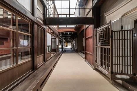
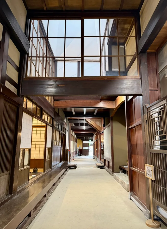
Evidence 2 — 通り庭 / Tori-niwa · The stones in the corridor
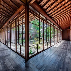
Step inside any of the open houses and the scale becomes physical. The 通り庭 / tori-niwa — a long earthen-floored corridor running straight from the street front to the old berth at the back — is paved with enormous flat stones brought as ship's ballast from 小豆島 / Shōdoshima, 600 kilometres to the southwest. The roof beams are black pine from 能登 / Noto. The board doors are 屋久杉 / Yakushima cedar. The materials come from everywhere the ships went. The house is a map of the trade, laid horizontally underfoot.
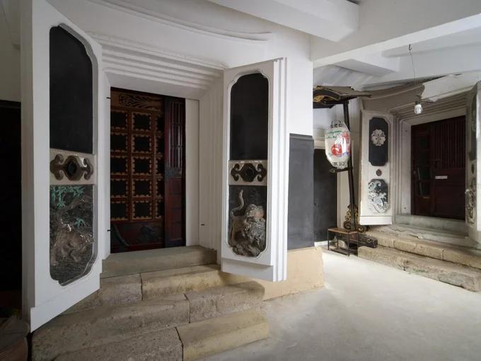
Evidence 3 — 鏝絵 / Kote-e · The relief on the storehouse door
In the rear courtyards stand the 土蔵 / dozō — fireproof earthen-walled storehouses where the cargo and the cash were kept. The doors of these storehouses carry 鏝絵 / kote-e — lacquer-plaster relief carvings worked directly into the earthen surface. Dragons. Tigers. Auspicious imagery, ostensibly. But the dragons and tigers are on the doors that opened onto money. The kote-e is not decoration; it is the public marking of the buildings worth defending.
Evidence 4 — 御蔵町 / Mikura-cho · The name of the neighbourhood
Walk a block back from the main street and the addresses begin to include the syllables 御蔵町 / Mikura-cho — Storehouse Quarter. This is where the Kaga domain kept the rice it had collected as tax before loading it onto the ships. The storehouses themselves are mostly gone. The neighbourhood name is not. A street sign is a slow form of evidence. It will outlast almost everything else.
The work of a second life is mostly invisible. It happens in the public decisions that no one photographs, the buildings that change purpose without changing shape, the schedules that pause for repair.
Second Life 1 — 電線地中化 / Buried lines · The first decision
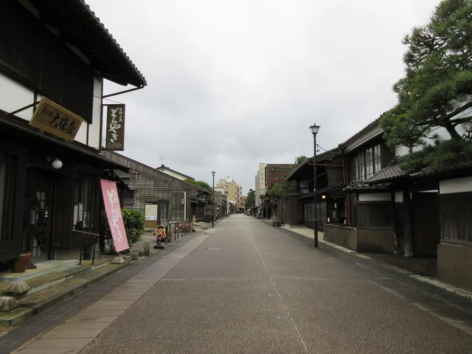
The four-hundred-metre stretch of 岩瀬大町・新川町通り / Iwase Omachi and Shinkawa-cho has had its overhead wires removed and routed underground. The work is municipal, slow, and expensive. It also produces an effect that older streetscape photographs of Japan rarely show: a continuous strip of sky above the historic façades. The decision is not about heritage tourism. It is about choosing what a working street should look like when the people who live and work on it look up.
Second Life 2 — ベージュ舗装 / The pale pavement · A surface to match
The same street has been resurfaced in a pale beige tone rather than the usual black asphalt. The colour is not decorative either. Black asphalt reads as urban infrastructure; the beige reads as continuous with the earthen and stone surfaces of the merchant courtyards behind the façades. The road still carries cars, residents, and the occasional delivery van. It simply does so on a surface that does not visually argue with the buildings it passes.
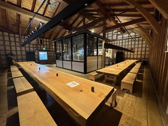
Second Life 3 — 米蔵 → ブルーパブ / Rice warehouse to brew pub · A change of contents
At the rear of the 旧馬場家住宅 / Kyū Baba-ke — the leading household of the so-called Iwase Five — stands a 19th-century 米蔵 / kome-gura, rice storehouse. The thick earthen walls that once regulated the temperature of stored grain now hold tanks of beer. The building is operated as KOBO Brew Pub, with brewers from the Czech Republic and Slovakia. The exterior is unchanged. The contents are not. This is the kind of conversion that takes the building's structural logic seriously: a warehouse that was built to keep things stable on the inside is still keeping things stable on the inside.
Second Life 4 — 旧森家住宅 / Kyū Mori-ke · A pause to repair
At the centre of the merchant row stands the 旧森家住宅 / Kyū Mori-ke, built around 1878 and designated a nationally important cultural property. It is currently closed to the public. The 2024 earthquake on the Noto Peninsula reached this coast as well, and the house is undergoing seismic retrofit work; reopening is scheduled for fiscal 2027 or later. A long-shut house is also a form of second life — the version where the town chooses repair over display, and accepts the inconvenience.
None of this is restoration in the museum sense. The street has not been frozen. It has been adjusted — the overhead wires, the pavement colour, the contents of a warehouse, the schedule of a public building — by people deciding what a four-hundred-year-old port should be for next.
Where to stand on the four-hundred-metre street.
Six places to visit, each chosen because it makes the changes described in THE EVIDENCE and THE SECOND LIFE visible from the street. Open houses, working shops, a tower with a view. Two of the six are closed at the time of writing; both are listed because their closure is part of how the town is rebuilding itself.
STAY & TASTE 1 — 旧馬場家住宅 / Kyū Baba-ke
Open to the public. Free entry on the ground floor (verify on arrival).
The leading household of the so-called Iwase Five — a complete early-Meiji merchant compound with a thirty-metre tori-niwa and a 19th-century kome-gura at the rear. The single most important stop on the four-hundred-metre street.
→ Open in Google Maps
STAY & TASTE 2 — 沙石/ Saseki
Sake standing bar (kaku-uchi). Walk-in.
A 19th-century merchant house with an intact sumusiko façade, now operated as a tasting room for Masuizumi sake from the brewery a few buildings away. A sumusiko you can walk through.
→ Open in Google Maps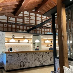
STAY & TASTE 3 — KOBO Brew Pub
Craft brewery and pub. Walk-in.
In the rear kome-gura of the Kyū Baba-ke estate. The earthen walls that once stabilised stored rice now hold tanks of beer. Brewed with sake lees from the Masuda brewery next door.
→ Open in Google Maps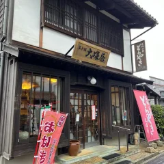
STAY & TASTE 4 — 大塚屋 / Otsukaya
Confectionery shop. Walk-in.
A long-established sweet shop on the merchant row, best known for a triangular variant of dorayaki that exists nowhere else. A counter that kept opening through the long quiet between the trade and now.
→ Open in Google Maps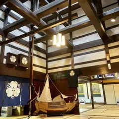
STAY & TASTE 5 — 旧森家住宅 / Kyū Mori-ke (closed)
Currently closed for seismic retrofit. Reopening scheduled for fiscal 2027 or later.
A nationally important cultural property built around 1878, currently closed for seismic retrofit after the 2024 Noto Peninsula earthquake. Visit the gate; the closure notice is part of the article.
→ Open in Google Maps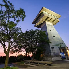
STAY & TASTE 6 — Toyama Harbour Observation
Free entry. Verify hours on arrival.
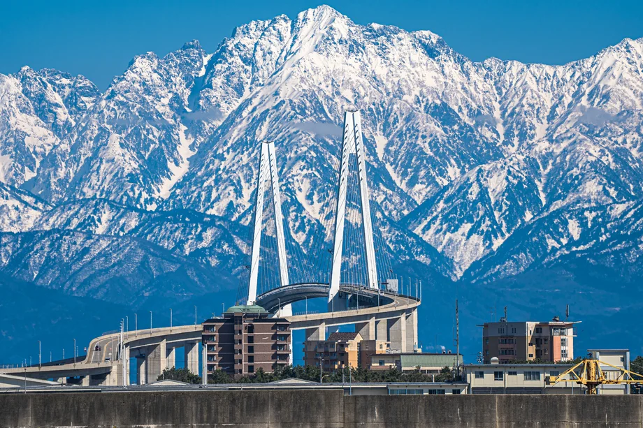
A 20-metre tower modelled on the jōyatō harbour lanterns that once guided Kitamaebune crews into the channel. From the top: the canal mouth, the modern port, and — on a clear day — the Tateyama range behind the sea.
→ Open in Google MapsArrive in a way that already begins the story.
Two routes carry you in: a light rail that follows the old freight spur to the sea, and a canal boat that rises 2.5 metres through a 1934 lock on the way. Either one tells you something about the port before you arrive.
Access — ポートラム / Portram
The light rail from Toyama Station follows the old freight spur to the coast, reaching Higashi-Iwase Station in about 25 minutes. The line runs through suburbs and light industry before arriving, abruptly, at the old merchant row. The transition is the point: you are somewhere most visitors to Toyama have not been.
Access — 富岩水上ライン / Fugan Water Line
A canal boat from Fugan Canal Kansui Park, ten minutes' walk from Toyama Station. Midway, the Nakajima Lock Gate — a national important cultural property completed in 1934 — raises the boat 2.5 metres on the Panama Canal principle. The boat sits in the chamber while water fills around it. The correct way to understand Higashi-Iwase: not a town beside the sea, but a town the sea came into. Schedule and booking: fugan-suijo-line.jp/en
Model course
Arrive at Higashi-Iwase Station by Portram, then rent a bike at Iwase Canal Hall (¥500 standard / ¥1,000 crossbike) for a 3.5–4 hour loop.
Kyū Baba-ke — open. The clearest tori-niwa on the row.
Iwase Omachi & Shinkawa-cho — the cable-free main street; sky as it read in the 19th century.
Mikura-cho — walk a block back from the main street. Read the address signs.
Toyama Harbour Observation Tower — 20m, free, modelled on the jōyatō harbour lanterns. Tateyama behind the sea on a clear day. (Closer from Iwasehama Station, the next stop north.)
Saseki or KOBO Brew Pub — sit down for thirty minutes on the same street.
Logistics
Portram from Toyama Station, approx. every 10–15 min, ~25 min to Higashi-Iwase Station (one stop short of the terminus at Iwasehama). Fugan Water Line from Kansui Park, seasonal, reservation recommended. Bicycle hire at Iwase Canal Hall (¥500 standard / ¥1,000 crossbike).